Geologic map of the Chokecherry Mountain quadrangle, Lincoln County, Nevada
Authors: Peter D. Rowley, Lawrence W. Snee, Ralph R. Shroba, W C Swadley, and F. William Simonds
Year: 2023
Series: Open-File Report 2023-09
Format: map sheet with cross sections: 36 x 28 inches, color; text: 31 pages, b/w
Scale: 1:24,000
This geologic map is one of two geologic quadrangles of the Caliente caldera complex to be published in 2023 by the Nevada Bureau of Mines and Geology (NBMG); five more quadrangles are anticipated. These result from mapping and related petrologic, geochemical, and isotopic studies by the authors that were funded by the U.S. Geological Survey (USGS) in the late 1980s to middle 1990s. The mapping was part of a large USGS project named the Basin and Range to Colorado Plateau Transition (BARCO) study in southeastern Nevada, southwestern Utah, and northwestern Arizona. Mapping was to be published by the USGS at detailed (1:24,000) scale, then compiled in 1:100,000-scale quadrangles. The project ended in early 1995 during the USGS Reduction in Force (RIF).
One of the subprojects of BARCO was a study of the Caliente caldera complex and its gold deposits, led by the senior author. Mapping at 1:24,000 scale began at the western end of the caldera complex, but only three quadrangles were published (Rowley and Shroba, 1991; Rowley et al., 1994; Swadley and Rowley, 1994). Abstracts cited here and summary reports (e.g., Rowley et al., 1992, 1995, 2001; Best et al., 1993; Hudson et al., 1995, 1998; Nealey et al., 1995; Unruh et al., 1995; Scott et al., 1995a, b) also were prepared before the RIF, with some published after. The seven quadrangles we intend to complete were mapped but never published. We also intend to publish with NBMG many 40Ar/39Ar dates by L.W. Snee, most of them from rocks in the caldera complex, that were never released in final form (e.g., Snee et al., 1990; Snee and Rowley, 2000). Funding from the USGS STATEMAP program awarded to NBMG has permitted synthesis and completion of our research in the area and publication of these quadrangles.
The physiography of the Chokecherry Mountain quadrangle consists mostly of the central to northern Delamar Mountains, with the central Burnt Springs Range in the northwestern part of the map area. Southern Dry Lake Valley and northern Delamar Valley lie west of the quadrangle. The other map to be published this year, the Caliente NW quadrangle to the north (Rowley et al., 2023), contains the northern Delamar Mountains, the northern Burnt Springs Range, and several small unnamed ranges. The Caliente quadrangle to the east of the map area consists of the eastern Delamar Mountains and magnificent south-flowing Rainbow Canyon that forms the eastern edge of the Delamar Mountains. The railroad town of Caliente lies in the northern end of Rainbow Canyon, where Newman Canyon joins Rainbow Canyon from the west and Clover Creek joins Rainbow Canyon from the east. North and northeast of the Caliente quadrangle, the areas of the eastern Antelope Canyon basin, Chief Range, and southern Panaca basin were mapped by Rowley and Shroba (1991) and Rowley et al. (1994). West of the map area, the western Dry Lake Valley, southern Burnt Springs Range, and part of the western Delamar Mountains were mapped by Swadley and Rowley (1994).
Geologic map of the Chokecherry Mountain quadrangle, Lincoln County, Nevada [MAP AND TEXT]

Geologic map of the Caliente NW quadrangle, Lincoln County, Nevada
Authors: Peter D. Rowley, Ralph R. Shroba, W C Swadley, F. William Simonds, Lawrence W. Snee, and Gary J. Axen
Year: 2023
Series: Open-File Report 2023-10
Format: map sheet with cross sections: 37 x 30 inches, color; text: 25 pages, b/w
Scale: 1:24,000
This geologic map is one of two geologic quadrangles of the Caliente caldera complex to be published in 2023 by the Nevada Bureau of Mines and Geology (NBMG); five more are anticipated. These result from mapping and related petrologic, geochemical, and isotopic studies by the authors that were funded by the U.S. Geological Survey (USGS) in the late 1980s and early 1990s. The mapping was part of a large project named the Basin and Range to Colorado Plateau Transition (BARCO) study in southeastern Nevada, southwestern Utah, and northwestern Arizona. Mapping was to be published at detailed (1:24,000) scale, then compiled in 1:100,000-scale quadrangles. The project ended in early 1995 during the USGS Reduction in Force (RIF).
One of the subprojects of BARCO was a study of the Caliente caldera complex and its gold deposits, led by the senior author. Mapping at 1:24,000 scale began at the western end of the caldera complex, but only three quadrangles were published (Rowley and Shroba, 1991; Rowley et al., 1994; Swadley and Rowley, 1994). Abstracts cited here and summary reports (e.g., Rowley et al., 1992, 1995, 2001; Best et al., 1993; Hudson et al., 1995, 1998; Nealey et al., 1995; Unruh et al., 1995; Scott et al., 1995a, b) also were prepared before the RIF, with some published after. The seven quadrangles we intend to complete were mapped but never published. We also intend to publish with NBMG many 40Ar/39Ar dates by L.W. Snee, most of them from rocks in the caldera complex, that were never released in final form (e.g., Snee et al., 1990; Snee and Rowley, 2000).
The physiography of the Caliente NW quadrangle consists of the northern end of the Delamar Mountains and several small ranges to the north, the Burnt Springs Range on the west and unnamed ranges east of it. In the Caliente NW quadrangle, west of these mountain clusters is the eastern edge of broad Dry Lake Valley, and east of the mountain clusters is the western part of the Antelope Canyon basin. The other map to be published in 2023, the Chokecherry Mountain quadrangle to the south (Rowley et al., 2023), contains the central to northern Delamar Mountains and the central Burnt Springs Range. East of the Caliente NW map area, the Chief Range and eastern Antelope Canyon basin were mapped by Rowley et al. (1994). Southwest of the map area, the western Dry Lake Valley, southern Burnt Springs Range, and western Delamar Mountains, including the western edge of the Delamar caldera, were mapped by Swadley and Rowley (1994).
Geologic map of the Caliente NW quadrangle, Lincoln County, Nevada [MAP AND TEXT]
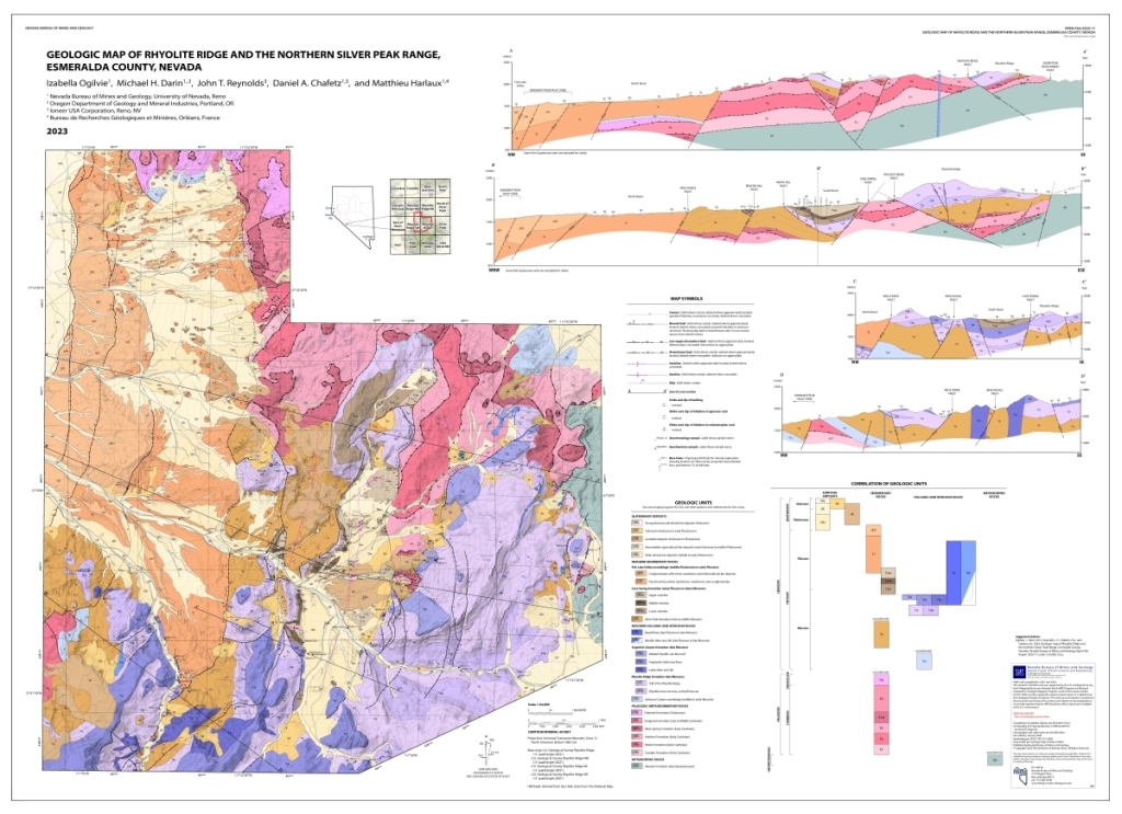
Geologic map of Rhyolite Ridge and the northern Silver Peak Range, Esmeralda County, Nevada
Authors: Izabella Ogilvie, Michael H. Darin, John T. Reynolds, Daniel A. Chafetz, and Matthieu Harlaux
Year: 2023
Series: Open-File Report 2023-11
Format: map sheet with cross sections: 41 x 29.5 inches, color; text: 35 pages, color
Scale: 1:24,000
Rhyolite Ridge is located in the northern Silver Peak Range of southwestern Nevada and contains significant sediment-hosted lithium and boron deposits that are nearing development. Despite the economic importance of these resources, the primary source of lithium, deformation history, and the relative influences of structural, stratigraphic, and magmatic controls on lithium enrichment are uncertain. This report presents new 1:24,000-scale geologic mapping, whole-rock geochemistry, and a sub-regional compilation of Cenozoic geochronologic data to support the evaluation and assessment of these critical minerals through the U.S. Geological Survey (USGS) Earth Mapping Resources Initiative (Earth MRI). Most of the economic lithium and boron mineralization occurs in the upper Miocene to lower Pliocene Cave Spring formation, which is composed of interbedded lacustrine claystone, marl, limestone, volcaniclastic rocks, and tuffs. Anomalously high concentrations of lithium (up to 2,620 ppm; Reynolds and Chafetz, 2020) are bound in marl, smectite, and mixed illite-smectite clays, while boron is primarily associated with searlesite. The Cave Spring formation is mostly contained within a single structural basin in the study area and was deposited in an alluvial-lacustrine environment on top of ~6.1–5.8 Ma rhyolitic tuffs and lavas of the Rhyolite Ridge and Argentite Canyon formations. Geochemical data from these pre-basin volcanic rocks contain exceptionally high whole-rock lithium concentrations up to 451 ppm, though with notable spatial heterogeneity. The high lithium (and boron) concentrations and considerable spatial extent and volume of these rhyolites implicate them as a probable source for the mineralization in the Cave Spring formation. The White Hill and Cave Spring faults are a pair of conjugate normal faults that controlled deposition of the Cave Spring formation in an internally drained, alluvial-lacustrine basin that experienced WNW-directed extension since latest Miocene time (Ogilvie, 2023). Field relations, subsurface well data, airborne electromagnetic surveys, and our synthesis of geochronologic constraints indicate a similar style of extension across the study area associated with both NW- and SE-dipping normal faults. Active faulting and basin subsidence continues today near the western map boundary along the Emigrant Peak fault zone that bounds northern Fish Lake Valley.
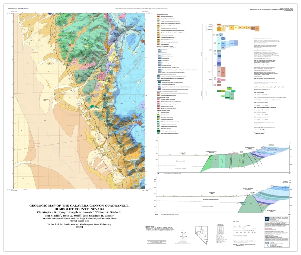
Geologic map of the Calavera Canyon quadrangle, Humboldt County, Nevada
Authors: Christopher D. Henry, Joseph A. Laravie, William A. Starkel, Ben S. Ellis, John A. Wolff, and Stephen B. Castor
The Calavera Canyon 7.5-minute quadrangle covers the western margin of the 16.4 Ma McDermitt caldera, one of the oldest expressions of the Yellowstone hotspot and site of major lithium-clay deposits, and the eastern part of the adjacent Kings River Valley, a significant agricultural center. The ~800-m-high topographic scarp between the two areas exposes the caldera ring-fracture zone, extensive pre- caldera rocks, and a complete section of intracaldera tuff. The oldest pre-caldera rocks are a diverse suite of Jurassic intrusive rocks (table 1) that mostly consists of granodiorite but spans from high-Si felsite, aplite, and pegmatite to gabbro (table 2). Two major pulses of Eocene volcanism at 46–47 Ma and 39–41 Ma (table 3) produced dacite to rhyolite lavas and andesite-dacite(?) lavas, respectively (table 2). The lavas and volcaniclastic rocks coeval with the younger pulse filled a west-trending paleovalley cut into the Jurassic intrusive rocks. After a hiatus until ~17 Ma, intensive volcanic activity resumed with eruption of basalt and basaltic andesite lavas that are some of the southernmost expressions of Columbia River Basalt magmatism. Volcanism became more silicic with time, initially with anorthoclase-bearing rhyolite lavas, followed by biotite rhyolite lava domes, and peralkaline rhyolite lavas. Volcanism culminated with ~16.4 Ma eruption of ~1000 km3 of McDermitt Tuff, which is zoned from aphyric, peralkaline, high-Si rhyolite to abundantly anorthoclase-phyric trachydacite and icelandite (Fe-rich andesite). Eruption induced collapse of the ~40 x 22–30 km McDermitt caldera. Collapse along the western margin in the Calavera Canyon quadrangle was accommodated by an as much as 1 km wide zone of east-dipping, high-angle faults and monoclinal downwarps into the caldera. A lake that formed within the caldera was subsequently filled with tuffaceous sediments until ~15.7 Ma.
Normal faulting that probably began about 11–12 Ma in the McDermitt region (Colgan et al., 2006) cut through the western edge of the caldera, exposing the considerable intracaldera sequence in the quadrangle. The resulting, west-dipping Montana Mountains fault zone separates bedrock in the eastern part of the quadrangle from thick Quaternary and latest Cenozoic deposits in Kings River Valley. An as much as ~8-m-high scarp demonstrates that faulting has continued to the present. Quaternary deposits include alluvium, alluvial-fan deposits, and extensive colluvium and talus in drainages and slopes in bedrock and extending out into the valley. A pluvial lake occupied the valley into the Holocene, deposited both fine sediments in the lake bottom and gravel along shorelines and spits, and generated numerous shorelines during lake recession.
Three types of mineralization are present in the quadrangle. 1. Lithium-rich clays in the intracaldera sedimentary deposits, first recognized in the 1970s (Rytuba and Glanzman, 1979), are currently most important because of demand for Li for Li-ion batteries. The deposits also contain significant K, Rb, Mo, As, Sb, Mg, and F (Castor and Henry, 2020). The uncertain origin of these deposits involves diagenesis of the host tuffaceous sediments and possibly hydrothermal activity during the waning stages of caldera magmatism (Castor and Henry, 2020; Benson et al., 2017a, 2023). 2. U-Zr mineralization in pre-caldera volcanic rocks in and along caldera collapse faults at the Moonlight Mine and in Horse Canyon formed from hydrothermal solutions immediately following collapse (table 1; Castor and Henry, 2000). These deposits mostly consist of U-rich zircon, are accompanied by As, Sb, and Hf; minor amounts of Cu, Zn, Y, Hg, and Pb; and locally Mo, Ag, and Tl (table 4). 3. Quartz-sulfide veins in the Jurassic granitic rocks produced an unknown but probably small amount of Au and Ag in the early 1900s (Willden, 1964; Minor et al., 1988). Analyses of two vein samples for this study show minor enrichment in Co, Cu, As, Mo, Ag, Sb, Hg, and Bi (Au not analyzed; table 4).
Geologic map of the Calavera Canyon quadrangle, Humboldt County, Nevada [MAP AND TEXT]