New Geologic Map – Kinsley Mountains

Preliminary Geologic Map of the Kinsley Mountains, Elko and White Pine Counties, Nevada
Authors: John L. Muntean, Seth Dee, Tyler J. Hill, Randall L. Hannink, Moira Smith, Gene Urie, and Ken Raabe
Year: 2017
Series: Open-File Report 2017-07
Version: first edition, September 2017; supersedes Open-File Report 15-9
Format: plate: 41 x 54.5 inches, color; text: 5 pages, b/w
Scale: 1:12,000
View/Download/Purchase:

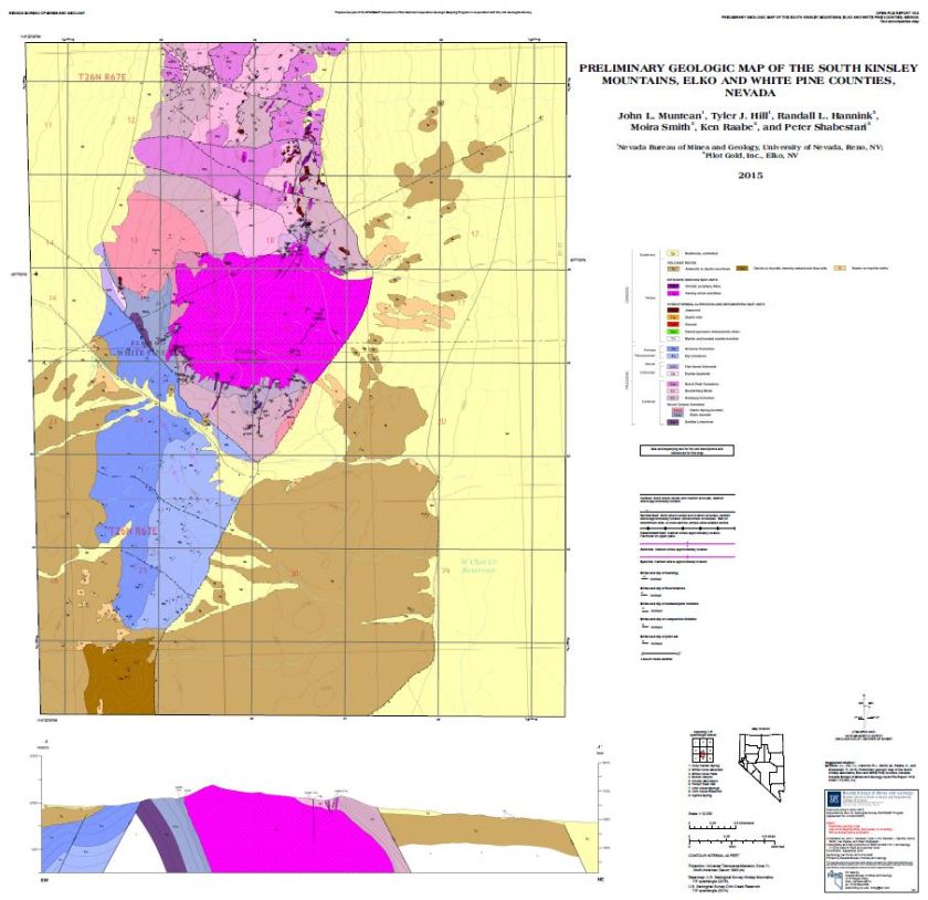
This detailed geologic mapping of the Kinsley Mountains in eastern Nevada investigates the time-space relationships between an Eocene intrusive complex centered on a granitic stock, proximal intrusion-related polymetallic skarn and carbonate replacement mineralization, disseminated Carlin-style gold deposits 3 km north of the stock, Eocene magmatism, and Eocene through Quaternary faulting. Previous detailed mapping of the northern Kinsley Mountains by geologists of Pilot Gold was compiled, field checked, and refined, along with new mapping during the summers of 2015 and 2017. Pilot Gold is exploring for more Carlin-style mineralization in the center of the range and map area, where gold ore was previously mined in the late 1990s. The mapping revealed: 1) a significant amount of extensional faulting occurred prior to Eocene magmatism and mineralization, similar to what NBMG mapping documented recently in the Eureka mining district. Eocene intrusions cut faults or fill faults, and Eocene volcanic rocks unconformably overlie Paleozoic rocks as old as Ordovician and as young as Permian, 2) Eocene dikes, gossans, and quartz veins, and jasperoid formation are focused within a 1-km-wide corridor that extends 3 km northward from the stock to the area of carbonate-hosted Carlin-like gold deposits, where dikes in drill core have locally high gold grades, 3) significant Eocene extension is demonstrated by a southwest-dipping fault that dropped Permian rocks against metamorphosed and mineralized Cambrian rocks proximal to the Eocene stock; the fault is overlapped by Eocene volcanic rocks that are a few million years younger than the stock, suggesting the intrusive complex was rapidly exhumed nearly 3 km, and 4) detailed mapping of the Quaternary range front fault on the east side of the mountains demonstrates offset of alluvial-fan deposits of likely mid-Pleistocene age with no faulting in younger Quaternary deposits.

This map was prepared as a part of the STATEMAP component of the National Cooperative Geologic Mapping Program in cooperation with the U.S. Geological Survey under STATEMAP award number G16AC00186, 2017.

New Geologic Map – Independence Valley NW

Preliminary Geologic Map of the North Half of the Independence Valley NW Quadrangle and the Adjacent Part of the Independence Valley NE Quadrangle, Elko County, Nevada
Author: Seth Dee, Christopher D. Henry, Michael W. Ressel, and Andrew V. Zuza
Year: 2017
Series: Open-File Report 2017-06
Version: first edition, September 2017
Format: plate: 35 x 30.5 inches, color; text: 4 pages, b/w
Scale: 1:24,000
View/Download/Purchase:
http://pubs.nbmg.unr.edu/Prel-geo-Indep-Valley-NW-p/of2017-06.htm

The north half of the Independence Valley NW 7.5-minute quadrangle covers a part of the western Pequop Mountains and adjacent Independence Valley in eastern Elko County. The east-tilted Pequop Mountains have newly recognized Carlin-type gold deposits in a geographic and geologic setting distinct from similar deposits elsewhere in Nevada. Mapping in the quadrangle was done in the summer of 2017.

Southeast-dipping Cambrian through Ordovician sedimentary rocks are exposed in the range front along the eastern edge of the map area. Eocene rhyolite dikes and sills, and Cretaceous granitic sills and pods locally intrude the oldest Cambrian stratigraphy. The Eocene intrusions may be part of a magmatic system that produced the heat source for the nearby Carlin-type mineralization. The range front is bound on the west by two west-dipping normal fault systems that accommodated late Cenozoic exhumation. Exposed in the hanging wall of the eastern fault system are late Cenozoic basin deposits that uncomfortably overlie Cambrian through Ordovician sedimentary rocks. Logs from three boreholes drilled into the Paleozoic rocks of the hanging wall during mineral exploration were used to help develop cross section A–A’’. One of the boreholes encountered an approximately 60-m-thick zone of fault gouge and a fault sliver with repeated Ordovician stratigraphy. This fault zone is interpreted to place Permian Pequop Formation above Ordovician Fish Haven Dolomite and may be correlative with the enigmatic Pequop fault observed in the adjacent Pequop Summit and Independence Valley NE quadrangles and variably interpreted as a thrust (Thorman, 1970) or a low-angle normal fault (Camilleri, 2010). Another borehole was advanced through the eastern range-front fault and constrains the dip of the fault to 34° west. Correlation of stratigraphy across the eastern range-front fault suggests approximately 4 km of total dip-slip displacement during Cenozoic exhumation.

The oldest Cenozoic basin deposits exposed between the two range front fault systems are tuffaceous sediments with a maximum measured bedding dip of 34° east. The tuffaceous sediments are overlain by a megabreccia landslide deposit with individual bedrock blocks over 200 m long. The individual blocks have lithologic and textural characteristics similar to rocks exposed along the western flank of the modern Pequop Mountains, which may have been the source of these megabreccia deposits. The megabreccia is overlain by Pliocene(?) fanglomerate deposits with nearly horizontal bedding.

The western range-front fault, named the Independence Valley fault zone, has evidence for late-Quaternary activity. In the footwall of the fault, alluvial-fan deposits of probable middle Pleistocene age are beveled onto the Cenozoic sediments. Late Quaternary displacement along the Independence Valley fault zone has uplifted these fan deposits a minimum of 30 m. The youngest fan deposits offset by the fault zone are of probable latest Pleistocene age, and are displaced by fault scarps up to 3 m high.

In Independence Valley, lacustrine gravels are deposited on shorelines, beach bars, and spits recording the high-stand and recessional stages of latest Pleistocene Lake Clover (Munroe and Laabs, 2013). An older lacustrine gravel deposit with a well-developed pedogenic carbonate soil horizon was mapped topographically above the latest Pleistocene shorelines along the western edge of the map area.

This geologic map was funded in part by the USGS National Cooperative Geologic Mapping Program under STATEMAP award number G16AC00186, 2017.

New Geologic Map – Boulder City NW

Preliminary Geologic Map of the Boulder City NW Quadrangle, Clark County Nevada
Author: Nicholas H. Hinz, Seth Dee, and Racheal Johnsen
Year: 2017
Series: Open-File Report 2017-05
Version: first edition, September 2017
Format: plate: 41 x 41.5 inches, color; text: 5 pages, b/w
Scale: 1:24,000
View/Download/Purchase:
http://pubs.nbmg.unr.edu/Prel-geol-Boulder-City-NW-p/of2017-05.htm

This 1:24,000-scale preliminary geologic map of the Boulder City NW 7.5-minute quadrangle in Clark County, Nevada covers portions of the southwestern River Mountains, the northeastern McCullough Range and straddles a segment of the drainage divide between the hydrologically closed Eldorado Valley and Las Vegas Valley which is part of the through-flowing Colorado River Basin. The City of Henderson extends into the north-central part of this quadrangle, and the in-progress Interstate 11, Boulder City Bypass transects the northeastern part of the quadrangle.

The bedrock exposures in the quadrangle include Tertiary plutonic, volcanic, and sedimentary rocks. The northeastern McCullough Range includes the ~14.5- to 13.8-Ma Railroad Pass pluton and corresponding ~15.0- to 13.9-Ma Dutchman Pass volcanics. The southwestern River Mountains is dominated by the pervasively hydrothermally altered Red Mountain volcanics. The Red Mountain volcanics are locally intruded by the ~14.5- to 13.5-Ma Boulder City pluton and locally overlain by the Dutchman Pass, Powerline Road, and Mount Davis volcanics.

The bedrock in the southern River Mountains contains numerous southerly strands of the dextral, NW-striking Las Vegas Valley shear zone, and the sinistral, NE-striking Lake Mead fault system, both major crustal structures during Miocene regional extension. The bedrock in the northeastern McCullough Range is cut by a system of kinematically linked north-striking, down-to-east normal faults and NW-striking dextral faults, the latter of which are associated with part of the southern termination of the Las Vegas Valley shear zone. The east side of the northern McCullough Range is bound by the Black Hills fault, which is an active range-front normal fault expressed as a continuous, 1.8- to 2.8-m-high fault scarp in late Pleistocene fan deposits. Mapping at the north end of the Black Hills fault suggests that the fault is directly linked to the sinistral, NE-striking Hemenway Wash fault, which is a major strand of the Lake Mead fault system, and that locally bounds the southern flank of the River Mountains. In contrast to the Black Hills fault, Quaternary fault scarps were not observed along the Hemenway Wash fault.

Surficial sediments in the quadrangle are largely alluvial fan and pediment deposits ranging from historic to early Pleistocene. Fan deposits eroded from altered Railroad Pass pluton locally contain clasts with actinolite and magnesiohornblende, which are naturally occurring asbestos (NOA) minerals.

This geologic map was funded in part by the USGS National Cooperative Geologic Mapping Program under STATEMAP award number G16AC00186, 2017.

Preliminary Geologic Map of the South Kinsley Mountains, Elko and White Pine Counties, Nevada

SouthKinsley
Authors:
John L. Muntean, Tyler J. Hill, Randall L. Hannink, Moira Smith, Ken Raabe, and Peter Shabestari
Year: 2015
Series: Open-File Report 15-9
Format: plate: 33 x 32 inches, color, includes 1 cross section; text: 3 pages, b/w
Scale: 1:12,000

This detailed geologic mapping of the southern Kinsley Mountains in eastern Nevada investigates the time-space relationships between an Eocene intrusive complex centered on a granitic stock, proximal intrusion-related polymetallic skarn and carbonate replacement mineralization, disseminated Carlin-style gold deposits 3 km north of the stock, faulting, and Eocene magmatism. Pilot Gold is currently exploring for more Carlin-style mineralization in the center of the range, just north of the completed map.

The mapping revealed the following:

1) A significant amount of extensional faulting occurred prior to Eocene magmatism and mineralization, similar to what NBMG mapping documented recently in the Eureka district. Eocene intrusions cut faults or fill faults.
2) Eocene dikes, gossans, and quartz veins, and jasperoid formation were focused within a 1-km-wide corridor that extends 3 km northward from the stock to the area of gold deposits, where dikes in drill core have locally high gold grades.
3) Significant Eocene extension is demonstrated by a southeast-dipping fault that dropped Permian rocks against metamorphosed and mineralized Cambrian rocks proximal to the Eocene stock. The fault is overlapped by Eocene volcanic rocks that are a few million years younger than the stock, suggesting the intrusive complex was rapidly exhumed nearly 3 km. Mapping of the southern end of the range is the first half of a project to meld the mapping with Pilot Gold’s mapping of the northern half of the range to complete a map of the entire Kinsley Mountains.

This map was prepared as a part of the STATEMAP component of the National Cooperative Geologic Mapping Program in cooperation with the U.S. Geological Survey.

View or purchase here:
http://pubs.nbmg.unr.edu/Prel-geol-south-Kinsley-Mts-p/of2015-09.htm

Preliminary Geologic Map of the Pequop Summit Quadrangle, Elko County, Nevada


Pequop
Authors:
Christopher D. Henry and Charles H. Thorman
Year: 2015
Series: Open-File Report 15-8
Format: plate: 41 x 29 inches, color, includes 3 cross sections; text: 12 pages, b/w
Scale: 1:24,000

The Pequop Summit 7.5-minute quadrangle covers the northern Pequop Mountains and is just north of newly recognized Carlin-type gold deposits in a geographic and geologic setting distinct from those of long-known deposits to the west. Mapping was done from Summer 2014 to Summer 2015; digital cartography, cross sections, and unit descriptions were done in Fall to Summer, 2014–2015.

Major results of this work are as follows:

1) The map area contains a >5-km-thick section of Cambrian through Permian sedimentary rocks. A major unconformity between Permian and Mississippian rocks documents an episode of uplift and erosion in the Late Pennsylvanian.
2) All Paleozoic rocks were contractionally deformed and metamorphosed during the Mesozoic. Contraction was accomplished by a combination of thrust and attenuation faults; west-northwest-striking, probable tear faults; folding within less competent units; and intense brecciation of competent units.
3) Eocene igneous rocks include locally derived andesite-dacite lavas and rhyolite intrusions that are geochemically unrelated to the lavas but may have been the heat source for the Carlin deposits.
4) Cenozoic extension includes a middle Miocene pulse of ~40° east-tilting along west-dipping normal faults in the central and southern Pequop Mountains and modern faulting along range-bounding faults.
5) The northern Pequops are west tilted, and a northeast-striking, extensional anticline formed between oppositely dipping normal fault systems there.

Building on the stratigraphic-structural understanding from STATEMAP mapping, we are using other funds to further resolve the thermal and uplift history of the Pequop Mountains and to test conflicting interpretations of metamorphism and contraction, similarly conflicting interpretations of extension and exhumation, and the relation of deformation and magmatism to the origin of Carlin deposits.

This map was prepared as part of the STATEMAP component of the National Cooperative Geologic Mapping Program in cooperation with the U.S. Geological Survey.

View or purchase here:
http://pubs.nbmg.unr.edu/Prel-geol-Pequop-Summit-p/of2015-08.htm

Preliminary Geologic Map of the Sloan Quadrangle, Clark County, Nevada


Sloan
Authors:
Nicholas H. Hinz, Alan R. Ramelli, and Seth Dee
Year: 2015
Series: Open-File Report 15-7
Format: plate: 37 x 26 inches, color, includes 1 cross section; text: 4 pages, b/w
Scale: 1:24,000

A 1:24,000 scale, preliminary geologic map of the Sloan 7.5-minute quadrangle in Clark County, Nevada. This quadrangle straddles Interstate Highway 15 along the south side of Las Vegas Valley and abuts the drainage divide with Ivanpah Valley. The actively managed Sloan Quarry is located in the NW quarter of the quadrangle. The north half of the quadrangle includes new housing developments in the City of Henderson, the Henderson Executive Airport, and new developments in the unincorporated communities of Paradise, Enterprise, and Sloan. The southeastern margin of this map area covers the north end of Hidden Valley and contains parts of each of the following land use features: the Sloan Canyon National Conservation Area, the Sloan Canyon Rock Art Site, and the Sloan Rock Art Area of Critical Environmental Concern.

The bedrock exposures in the quadrangle consist of Paleozoic carbonate basement and Tertiary volcanic and sedimentary rocks. The Paleozoic stratigraphy includes the Early to Middle Devonian Sultan Limestone, the Late Devonian to Early Mississippian Crystal Pass Limestone, the Mississippian Monte Cristo Group, and the Late Mississippian to Early Permian Bird Spring Formation. Four sub-units in the commonly undivided lower part the Bird Spring Formation were distinguished in the Sloan quadrangle. The Tertiary section includes a complex section of fluvial gravels and volcanic rocks. The fluvial gravels reach 350 m thick, fill a previously unrecognized paleovalley segment with as much as 500 m of preserved paleotopography. The volcanic rocks include middle Miocene basalt, basaltic andesite, andesite, and dacite that were locally erupted. The lower-most volcanic rocks are intercalated with the uppermost fluvial gravels. The Paleozoic section was initially deformed during the Sevier and/or Laramide orogenies and were displaced along reverse faults, thrust faults, and strike-slip faults. Normal faults associated with Basin and Range extension cut the Paleozoic strata and the lower half of the Tertiary section. Faults were not observed cutting the upper half of the Tertiary strata or the Quaternary surficial deposits.

This map was prepared as a part of the STATEMAP component of the National Cooperative Geologic Mapping Program in cooperation with the U.S. Geological Survey.

View or purchase here:
http://pubs.nbmg.unr.edu/Prel-geol-Sloan-quad-p/of2015-07.htm